Nobody knows what happened before the evolution of humanity. But the hypothesis claims that the sea existed in the region of Nepal about 100 million years ago. According to the theory of tectonic plates, volcanic plates underneath present India and China collided about 50 million years ago. These plates within the earth’s crust propelled the flatland to rise, ultimately creating skyscraping mountains. Some 20 million years ago, it formed a long Himalayan chain, and the height still soars to this day.
The unbroken chain of Himalaya extends about 2500 km from the Hindu Kush ranges of Afghanistan and Pakistan in the west to the Arunachal Pradesh of India in the East. Within this range rises the lofty Kanchenjunga, Makalu, Everest, Lhotse, Manaslu, Annapurna, and Dhaulagiri (all exceeding 8000 m) in northern Nepal that stretches approximately 800 km from east to west while 250 m across.
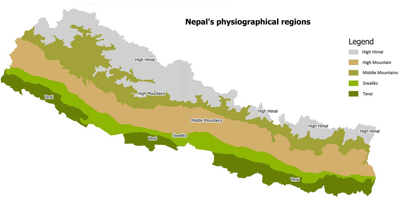
Based on the topography, Nepal is divided into 3 regions, namely: Upper-Himalayan, Middle-Hilly, and Lower-Terai.
Upper-Himalayan (over 3000 meters) is best characterized as a rocky region of Nepal comprising about 18% of the total land area. Pacing rivers intrude through the rocky ridges leading to the formation of several ravines and canyons, including the deepest gorge in the world at Kaligandaki. The trails are jagged and surrounded by alpine vegetation. Mesmerizing turquoise lakes hide between the snowy crags while the exquisite vantage points offer incredible insight into jaw-dropping snow-clad peaks. Undulating rocky cliffs is all that the Upper-Himalayan has at hand; flatlands are occasionally met. Zillions of river streams, waterfalls including other waterbodies originate from this region. Because of this, Nepal has titled the ‘Water towers of South-Asia’. The lower part of this region hosts a very limited population: especially the Sherpas and other indigenous tribes of Tibetan Origin. Further below is the Middle-Hilly region.
By its name, the Middle-Hilly region of Nepal features gentle slopes over the rolling hills carved into terraces for cultivation (mainly paddy) with dotted quaint settlements. Ravishing valleys of Kathmandu and Pokhara fall into this region including other medleys of unexplored valleys, which are as glamorous as the Kathmandu and Pokhara. Rivers descending from the mountainous region irrigate the farms at middle-hilly, rendering it an auspicious green outlook. Magars, Gurungs, Tamangs, and Newars inhabit this region, while the number of Brahmins and Chhetris is still significant. In the past Marijuana used to be cultivated in this region at a greater scale, but because of international pressure, the then government had to outlaw it in 1976. Below the altitude of 300m, the land of Terai opens up with great splendor.
Lower-Terai, generally characterized by a hot and damp climate, is a flatland ranging from an altitude of 60m to 300m. Being fenced by the Indian Borders on 3 sides, this region is crowded mainly by Madhesis and people of Indian Origin, who have been immune to the malarial insects for ages, while Brahmins, Chettris, Rais, and Limbus still hold a significant position. Most of the land is flat and fertile, making it suitable for agriculture. This region is more populated as compared to the hilly and Mountain region. Development projects are at pace, while most of the alleys are black-topped and are acquainted with modern-day sophistication.